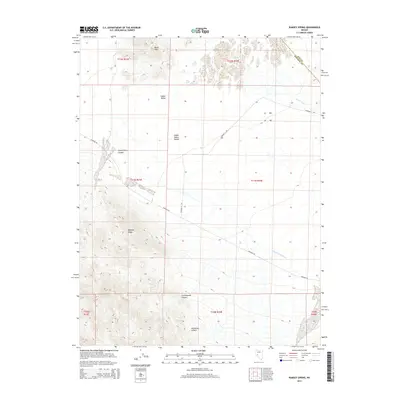
2014 Map of Ramsey Spring
USGS Topo · Published 2014About this map
Gabbs Valley and the Gabbs Valley Range define this high-desert landscape along the border of Nye and Mineral counties. The geography is marked by several seasonal drainages, including Gabbs Wash and Finger Rock Wash, which channel water toward the valley floor. In a region where water sources are vital, Ramsey Spring and Cottonwood Spring appear as critical landmarks for local history and ecology. Transportation across this arid basin is facilitated by unpaved routes like Rawhide Rd and Diamond A Rd, which cut through the complex topography of Mystery Ridge and the Black Hills. From the deep cuts of Superstition Canyon to the southern reach of Boundary Canyon, the map illustrates a network of named canyons and ridges that once supported the early ranching and prospecting efforts of central Nevada.
Find a feature on this map
21 named features on this map. Tap any name to fly to it.
Don’t see what you’re looking for? This feature index may not catch every label — zoom into the map to look around manually.
Map Details
Editions of this 2014 Ramsey Spring Map
This is the sole edition of this map. No revisions or reprints were ever made.
Other maps of this area

1909 · Hawthorne
USGS Topo · 1:250,000

1911 · Hawthorne
USGS Topo · 1:250,000

1915 · Hawthorne
USGS Topo · 1:250,000

1948 · Walker Lake
USGS Topo · 1:250,000

1957 · Walker Lake
USGS Topo · 1:250,000

1962 · Walker Lake
USGS Topo · 1:250,000

1964 · Walker Lake
USGS Topo · 1:250,000
1979 · Ramsey Spring
USGS Topo · 1:24,000
1979 · Win Wan Flat
USGS Topo · 1:24,000
1979 · Mount Annie SE
USGS Topo · 1:24,000