1996 Map of Rancho Santa Fe
USGS Topo · Published 2001About this map
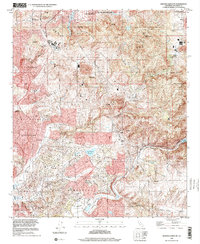
Rancho Santa Fe and the surrounding coastal canyons are documented here at the close of the 1990s, revealing a landscape defined by complex municipal boundaries and residential expansion into the hills. The map illustrates the sophisticated water infrastructure necessary for this arid region, featuring the San Dieguito Reservoir, a Filtration Plant, and the prominent Lake Hodges in the east. Notable peaks such as Mt Whitney and Franks Peak overlook the valleys where agricultural heritage meets modern development.
Find a feature on this map
38 named features on this map. Tap any name to fly to it.
Don’t see what you’re looking for? This feature index may not catch every label — zoom into the map to look around manually.
Map Details
Editions of this 1996 Rancho Santa Fe Map
This is the sole edition of this map. No revisions or reprints were ever made.
Other maps of this area

1893 · Oceanside
USGS Topo · 1:62,500

1893 · Escondido
USGS Topo · 1:62,500

1898 · Oceanside
USGS Topo · 1:62,500

1901 · Escondido
USGS Topo · 1:62,500

1901 · Oceanside
USGS Topo · 1:62,500

1901 · San Luis Rey
USGS Topo · 1:125,000

1903 · La Jolla
USGS Topo · 1:62,500

1904 · Southern California Sheet No. 2
USGS Topo · 1:250,000

1930 · La Jolla
USGS Topo · 1:62,500

1942 · Poway Valley
USGS Topo · 1:31,680