
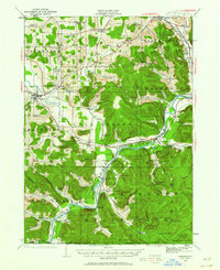
1922 Map of Randolph
USGS Topo · Published 1955About this map
The Allegheny River carves through this 1922 landscape, anchoring a region defined by the Allegheny Indian Reservation and the early development of Allegheny State Park. The map documents a dense network of early 20th-century rural education, featuring numerous named institutions such as the Friends Indian School, Oldtown School, and Seager Hill School. Settlement patterns follow the river and rail corridors, with communities like Steamburg and Red House situated along the Erie RR. To the south, the Pennsylvania RR serves riverfront hamlets including Onoville and Elko PO. The terrain is marked by family-named peaks and hollows, from Johnny Watt Hill to Hotchkiss Hollow, illustrating how 19th-century landholdings shaped the local geography before the expansion of state-managed parklands.
Find a feature on this map
109 named features on this map. Tap any name to fly to it.
Don’t see what you’re looking for? This feature index may not catch every label — zoom into the map to look around manually.
Map Details
Editions of this 1922 Randolph Map
2 editions found
Other maps of this area

1900 · Cherry Creek
USGS Topo · 1:62,500

1900 · Salamanca
USGS Topo · 1:62,500

1905 · Jamestown
USGS Topo · 1:62,500

1906 · Warren
USGS Topo · 1:62,500

1907 · Warren
USGS Topo · 1:62,500

1908 · Warren
USGS Topo · 1:62,500

1923 · Randolph
USGS Topo · 1:62,500

1923 · Cattaraugus
USGS Topo · 1:62,500

1924 · Ellicottville
USGS Topo · 1:62,500

1924 · Bradford
USGS Topo · 1:62,500