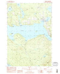
1984 Map of Rangeley
USGS Topo · Published 1985About this map
Rangeley Lake dominates this mid-1980s landscape, serving as the central hub for the township of Rangeley and the surrounding plantations. The map illustrates a well-developed recreational and residential infrastructure at the time, with Mingo Springs and Lakeside Park bordering the water while the Rangeley Lake State Park preserves the southern shoreline near South Bog. This era shows the region’s evolution into a destination for aviation and sport, evidenced by the Rangeley Municipal Airport and the nearby Golf Course.
Find a feature on this map
45 named features on this map. Tap any name to fly to it.
Don’t see what you’re looking for? This feature index may not catch every label — zoom into the map to look around manually.
Map Details
Editions of this 1984 Rangeley Map
This is the sole edition of this map. No revisions or reprints were ever made.
Other maps of this area

1931 · Cupsuptic
USGS Topo · 1:48,000

1932 · Kennebago Lake
USGS Topo · 1:48,000

1933 · Rangeley
USGS Topo · 1:48,000

1934 · Cupsuptic
USGS Topo · 1:62,500

1935 · Kennebago Lake
USGS Topo · 1:62,500

1935 · Cupsuptic
USGS Topo · 1:62,500

1936 · Kennebago Lake
USGS Topo · 1:62,500

1939 · Rangeley
USGS Topo · 1:62,500

1940 · Oquossoc
USGS Topo · 1:62,500

1942 · Oquossoc
USGS Topo · 1:62,500
Featured Places
- Rangeley, ME
- Dallas Plantation, ME
- Rangeley Plantation, ME
- Sandy River Plantation, ME
- Franklin County, ME