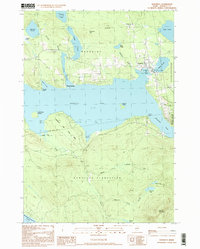
1997 Map of Rangeley
USGS Topo · Published 1999About this map
The town of Rangeley serves as the hub of this lakeside landscape, positioned where Hatchery Brook enters the northern reaches of Rangeley Lake. This late-twentieth-century study documents the intersection of Maine's recreation and local governance, showing the town's expansion toward Lakeside Park and the Rangeley Municipal Airport. The map highlights the distinct boundaries between Dallas Plantation, Sandy River Plantation, and Rangeley Plantation, reflecting a historical system of land organization unique to Maine. Significant water bodies including Haley Pond, Dodge Pond, and Quimby Pond surround the main settlement, while the southern shore is preserved by Rangeley Lake State Park. Landmarks like Mingo Springs and the local Cem provide specific points of interest for genealogists and local historians tracking the development of this highland community near the shores of Mooselookmeguntic Lake.
Find a feature on this map
43 named features on this map. Tap any name to fly to it.
Don’t see what you’re looking for? This feature index may not catch every label — zoom into the map to look around manually.
Map Details
Editions of this 1997 Rangeley Map
This is the sole edition of this map. No revisions or reprints were ever made.
Other maps of this area

1931 · Cupsuptic
USGS Topo · 1:48,000

1932 · Kennebago Lake
USGS Topo · 1:48,000

1933 · Rangeley
USGS Topo · 1:48,000

1934 · Cupsuptic
USGS Topo · 1:62,500

1935 · Kennebago Lake
USGS Topo · 1:62,500

1935 · Cupsuptic
USGS Topo · 1:62,500

1936 · Kennebago Lake
USGS Topo · 1:62,500

1939 · Rangeley
USGS Topo · 1:62,500

1940 · Oquossoc
USGS Topo · 1:62,500

1942 · Oquossoc
USGS Topo · 1:62,500
Featured Places
- Rangeley, ME
- Dallas Plantation, ME
- Rangeley Plantation, ME
- Sandy River Plantation, ME
- Franklin County, ME