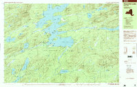
1997 Map of Raquette Lake
USGS Topo · Published 1999About this map
The Raquette Lake shoreline and its intricate network of bays and points dominate this central Adirondack landscape, documented in the late 1990s. The settlement of Raquette Lake sits at the western edge of the water, serving as a gateway to the Adirondack Park. To the south, the historic Sagamore estate area is centered around Sagamore Lake, illustrating the era of the great camps that defined regional development.
Find a feature on this map
79 named features on this map. Tap any name to fly to it.
Don’t see what you’re looking for? This feature index may not catch every label — zoom into the map to look around manually.
Map Details
Editions of this 1997 Raquette Lake Map
This is the sole edition of this map. No revisions or reprints were ever made.
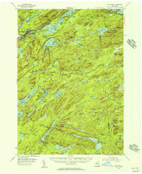
Other maps of this area

1899 · Indian Lake
USGS Topo · 1:62,500

1900 · Canada Lake
USGS Topo · 1:62,500

1901 · Old Forge
USGS Topo · 1:62,500

1902 · Indian Lake
USGS Topo · 1:62,500

1903 · Big Moose
USGS Topo · 1:62,500

1903 · West Canada Lakes
USGS Topo · 1:62,500

1903 · Raquette Lake
USGS Topo · 1:62,500

1903 · Blue Mountain
USGS Topo · 1:62,500

1950 · Utica
USGS Topo · 1:250,000
1954 · Old Forge
USGS Topo · 1:62,500