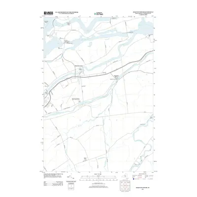
2013 Map of Raquette River
USGS Topo · Published 2013About this map
The Wiley Dondero Canal dominates the northern landscape of this region, facilitating heavy maritime traffic through the Eisenhower Lock and Snell Lock. These massive engineering features on the Saint Lawrence River define the modern character of the area, providing a stark contrast to the winding courses of the Grass River and Raquette River further south. Local genealogy is well-represented by several burial grounds, including Massena Center Cem and the Nevins Cem near the Massena International Airport-Richards Field. The industrial influence of the Aluminum Company is evident near the western edge of the map, while the rural interior is marked by small settlements like Massena Center and Maple Ridge. This survey captures the complex intersection of international shipping infrastructure and traditional upstate New York riverfront communities.
Find a feature on this map
78 named features on this map. Tap any name to fly to it.
Don’t see what you’re looking for? This feature index may not catch every label — zoom into the map to look around manually.
Map Details
Editions of this 2013 Raquette River Map
This is the sole edition of this map. No revisions or reprints were ever made.
Other maps of this area

1906 · Massena
USGS Topo · 1:62,500

1907 · Massena
USGS Topo · 1:62,500

1915 · Moira
USGS Topo · 1:62,500

1917 · Moira
USGS Topo · 1:62,500

1942 · Norfolk
USGS Topo · 1:24,000

1942 · Barnhart Island
USGS Topo · 1:24,000

1942 · Massena
USGS Topo · 1:24,000

1943 · Barnhart Island
USGS Topo · 1:31,680
1943 · Massena
USGS Topo · 1:31,680
1943 · Norfolk
USGS Topo · 1:31,680