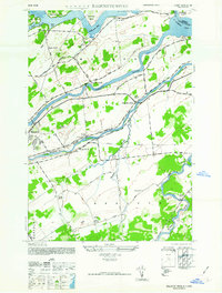
1946 Map of Raquette River
USGS Topo · Published 1946About this map
The St Lawrence River and its intricate northern boundary define this landscape in the mid-1940s, just before massive mid-century power and seaway projects altered these waters forever. The map reveals the river in its earlier state, featuring Barnhart Island and Long Sault I situated among the churning S Sault Rapids. Further south, the parallel flows of the Grass River and the Raquette River carve through the townships of Massena and Brasher.
Find a feature on this map
51 named features on this map. Tap any name to fly to it.
Don’t see what you’re looking for? This feature index may not catch every label — zoom into the map to look around manually.
Map Details
Editions of this 1946 Raquette River Map
This is the sole edition of this map. No revisions or reprints were ever made.
Other maps of this area

1906 · Massena
USGS Topo · 1:62,500

1907 · Massena
USGS Topo · 1:62,500

1915 · Moira
USGS Topo · 1:62,500

1917 · Moira
USGS Topo · 1:62,500

1942 · Norfolk
USGS Topo · 1:24,000

1942 · Barnhart Island
USGS Topo · 1:24,000

1942 · Massena
USGS Topo · 1:24,000

1943 · Barnhart Island
USGS Topo · 1:31,680
1943 · Massena
USGS Topo · 1:31,680
1943 · Norfolk
USGS Topo · 1:31,680