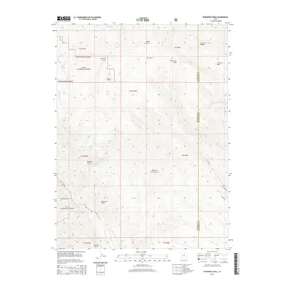
2014 Map of Raspberry Knoll
USGS Topo · Published 2014About this map
Uinta National Forest lands dominate this high-altitude landscape on the border of Wasatch and Duchesne counties. The terrain is defined by a series of prominent ridges and deep hollows, including the namesake Raspberry Knoll and the nearby Bobby Duke Ridge. Drainage systems like the Right Fork Little Red Cr and Left Fork Little Red Cr converge into Little Red Cr, while the winding course of Currant Cr cuts through the southwestern corner. Transportation in this backcountry is limited to narrow corridors like Currant Creek Rd and Pine Hollow Rd. This 2014 survey documents the complex topography of the western Uinta range, where features like Wagon Boss Canyon and McDonald Basin indicate a long history of local naming conventions tied to the livestock and timber industries that have historically shaped this part of Utah.
Find a feature on this map
29 named features on this map. Tap any name to fly to it.
Don’t see what you’re looking for? This feature index may not catch every label — zoom into the map to look around manually.
Map Details
Editions of this 2014 Raspberry Knoll Map
This is the sole edition of this map. No revisions or reprints were ever made.
Other maps of this area

1885 · Salt Lake
USGS Topo · 1:250,000

1885 · Uinta
USGS Topo · 1:250,000

1907 · Strawberry Valley
USGS Topo · 1:125,000

1909 · Strawberry Valley
USGS Topo · 1:125,000

1954 · Salt Lake City
USGS Topo · 1:250,000

1958 · Salt Lake City
USGS Topo · 1:250,000

1960 · Salt Lake City
USGS Topo · 1:250,000

1962 · Deep Creek Canyon
USGS Topo · 1:24,000
1962 · Wolf Creek
USGS Topo · 1:24,000

1962 · Fruitland
USGS Topo · 1:24,000