
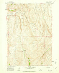
1957 Map of Rathbun Ranch
USGS Topo · Published 1958About this map
Scattered ranching operations define the remote drainages of Hot Springs County in the late 1950s, where seasonal grazing and water management dictate the settlement pattern. The landscape is structured around the winding course of Kirby Creek and its many tributaries, including West Kirby Creek and Ackles Fork. Family-held landholdings are the primary landmarks, ranging from the Hayes Winter Ranch and Gardner Winter Ranch in the north to the Rathbun Ranch and Bloomquist Ranch further south. These sites, along with the Day Homestead, represent a high-desert agricultural economy reliant on isolated water sources like the Kirby Reservoir. The terrain rises sharply toward the southern boundary at Lysite Mountain, while prominent landforms like Hall Butte provide navigational markers across the rugged breaks and draws of the Missouri River Basin development area.
Find a feature on this map
20 named features on this map. Tap any name to fly to it.
Don’t see what you’re looking for? This feature index may not catch every label — zoom into the map to look around manually.
Map Details
Editions of this 1957 Rathbun Ranch Map
This is the sole edition of this map. No revisions or reprints were ever made.
Other maps of this area

1952 · Rathbun Ranch
USGS Topo · 1:24,000

1952 · Arapahoe Butte
USGS Topo · 1:24,000

1952 · De Pass
USGS Topo · 1:24,000

1952 · Guffy Peak
USGS Topo · 1:24,000

1952 · Bull Mountain
USGS Topo · 1:24,000

1955 · Arminto
USGS Topo · 1:250,000

1958 · Arminto
USGS Topo · 1:250,000

1960 · Coyote Hill
USGS Topo · 1:24,000
1960 · Blue Hill
USGS Topo · 1:24,000

1960 · Packsaddle Creek
USGS Topo · 1:24,000