
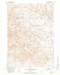
1952 Map of De Pass
USGS Topo · Published 1953About this map
Copper Mountain dominates the landscape of this Central Wyoming survey, where the extraction of ore and the isolation of high-altitude ranching defined local life in the mid-20th century. The presence of the De Pass Copper Mine (Inactive) and another Copper Mine (Inactive) nearby speak to a period of mineral prospecting along the steep slopes. Settlement patterns reflect the harsh environment, with family names attached to the terrain, including the Goedicke Homestead (Aband) and Nichols Ranch (Aband) already marked as abandoned by the early 1950s.
Find a feature on this map
35 named features on this map. Tap any name to fly to it.
Don’t see what you’re looking for? This feature index may not catch every label — zoom into the map to look around manually.
Map Details
Editions of this 1952 De Pass Map
2 editions found
Other maps of this area

1952 · Gates Butte
USGS Topo · 1:24,000

1952 · Rathbun Ranch
USGS Topo · 1:24,000

1952 · Picard Ranch
USGS Topo · 1:24,000

1952 · Lysite
USGS Topo · 1:24,000

1952 · Arapahoe Butte
USGS Topo · 1:24,000

1952 · Guffy Peak
USGS Topo · 1:24,000

1952 · Bull Mountain
USGS Topo · 1:24,000

1955 · Arminto
USGS Topo · 1:250,000

1957 · Rathbun Ranch
USGS Topo · 1:24,000

1958 · Arminto
USGS Topo · 1:250,000