
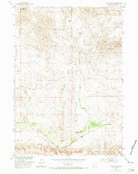
1952 Map of Picard Ranch
USGS Topo · Published 1953About this map
Picard Ranch and other isolated homesteads define this mid-century livestock and energy landscape in Fremont County. The terrain is deeply carved by drainage systems, most notably Badwater Creek and Hoodoo Creek, which shape the movement of local industry. This 1952 survey documents a transition in the region's economy, showing the Chicago and North Western railroad corridor running parallel to the creek while newer infrastructure like a Pipe Line and scattered oil wells begin to mark the valley floor.
Find a feature on this map
17 named features on this map. Tap any name to fly to it.
Don’t see what you’re looking for? This feature index may not catch every label — zoom into the map to look around manually.
Map Details
Editions of this 1952 Picard Ranch Map
2 editions found
Other maps of this area

1951 · Birdseye Pass
USGS Topo · 1:24,000

1951 · Bonneville
USGS Topo · 1:24,000

1951 · Shoshoni
USGS Topo · 1:24,000

1952 · Squaw Butte NE
USGS Topo · 1:24,000

1952 · Ocla Draw
USGS Topo · 1:24,000

1952 · Gates Butte
USGS Topo · 1:24,000

1952 · De Pass
USGS Topo · 1:24,000

1952 · Guffy Peak
USGS Topo · 1:24,000

1955 · Thermopolis
USGS Topo · 1:250,000

1955 · Arminto
USGS Topo · 1:250,000