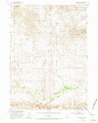
1952 Map of Picard Ranch
USGS Topo · Published 1973About this map
Picard Ranch and its neighbors sit within a complex network of drainage basins and rail corridors in Fremont County. Surveyed in the early 1950s, the landscape is defined by the confluence of major waterways like Badwater Creek and Hoodoo Creek. The infrastructure reflects a heavy reliance on the dual transit lines of the Chicago and North Western and the Burlington and Quincy railroads, which track alongside the southern creek beds. Notable family-named outposts including Howard Ranch and Fuller Ranch are scattered across the terrain between prominent landmarks such as Steffen Hill and Cedar Ridge. Evidence of past resource exploration appears in several locations, specifically marked as Well (Aband), suggesting a shift in land use or water access during this era of Missouri River Basin development.
Find a feature on this map
16 named features on this map. Tap any name to fly to it.
Don’t see what you’re looking for? This feature index may not catch every label — zoom into the map to look around manually.
Map Details
Editions of this 1952 Picard Ranch Map
2 editions found
Other maps of this area

1951 · Birdseye Pass
USGS Topo · 1:24,000

1951 · Bonneville
USGS Topo · 1:24,000

1951 · Shoshoni
USGS Topo · 1:24,000

1952 · Squaw Butte NE
USGS Topo · 1:24,000

1952 · Ocla Draw
USGS Topo · 1:24,000

1952 · Gates Butte
USGS Topo · 1:24,000

1952 · Picard Ranch
USGS Topo · 1:24,000

1952 · De Pass
USGS Topo · 1:24,000

1952 · Guffy Peak
USGS Topo · 1:24,000

1955 · Thermopolis
USGS Topo · 1:250,000