2023 Map of Ravena
USGS Topo · Published 2023About this map
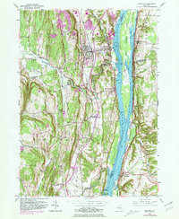
The Hudson River corridor serves as the primary axis for this survey, where the river's braided channels create a series of named landforms including Mull Island, Barren Island, and Houghtaling Island. Along the eastern bank, the settlement of Schodack Landing sits opposite Ravena and Coeymans, reflecting a long-standing pattern of river-oriented development. The inland topography to the west rises into features like High Rocks and Martins Hill, where smaller hamlets such as Aquetuck and Hannacroix are tucked among the drainage of Hannacrois Creek.
Find a feature on this map
123 named features on this map. Tap any name to fly to it.
Don’t see what you’re looking for? This feature index may not catch every label — zoom into the map to look around manually.
Map Details
Editions of this 2023 Ravena Map
This is the sole edition of this map. No revisions or reprints were ever made.