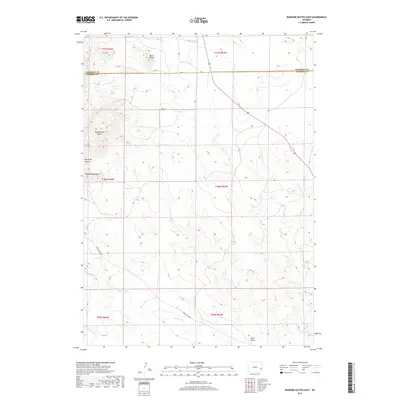
2017 Map of Rawhide Buttes East
USGS Topo · Published 2017About this map
Big Rawhide Butte and the surrounding high country define the western edge of this 2017 study of eastern Wyoming. Located along the boundary of Niobrara and Goshen counties, the map highlights the geological transition from the distinctive peaks of the Rawhide Buttes chain down to the drainage basins of J M Cr and Rawhide Cr. The landscape is largely defined by these watercourses and natural landmarks, including Mid Rawhide Butte and the remote Wolf Spring. A small network of rural routes such as Harris Ranch Rd and Co Rd 4 provides the only infrastructure across this high-plains terrain. This modern survey provides an exact record of the land's hydrology, including seasonal flows at Sand Draw and Negro-Baby Cr, illustrating the sparse but critical water resources in this part of the state.
Find a feature on this map
21 named features on this map. Tap any name to fly to it.
Don’t see what you’re looking for? This feature index may not catch every label — zoom into the map to look around manually.
Map Details
Editions of this 2017 Rawhide Buttes East Map
This is the sole edition of this map. No revisions or reprints were ever made.
Other maps of this area

1896 · Patrick
USGS Topo · 1:125,000

1896 · Hartville
USGS Topo · 1:125,000

1901 · Hartville
USGS Topo · 1:125,000

1951 · Moore Spring
USGS Topo · 1:24,000

1954 · Torrington
USGS Topo · 1:250,000

1958 · Torrington
USGS Topo · 1:250,000
1974 · Jay Em NW
USGS Topo · 1:24,000

1974 · Silver Springs
USGS Topo · 1:24,000

1974 · Jay Em
USGS Topo · 1:24,000

1974 · Rawhide Buttes East
USGS Topo · 1:24,000