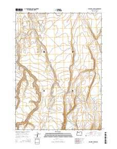
2014 Map of Rawhide Canyon
USGS Topo · Published 2014About this map
Rawhide Canyon cuts through this high desert landscape of Harney County, illustrating the remote drainage patterns of eastern Oregon. The intermittent flow of Wilson Cr serves as the primary hydrological axis, feeding into the North Wilson Reservoir in the northern reaches of the quadrangle. This area is characterized by scattered water sources essential for land management, such as the Boyce Waterhole, which provide critical points of interest for those studying the history of ranching and resource allocation in the Great Basin. The terrain transitions south toward Mule Valley, where the Public Land Survey System grid reveals the underlying township and range structure that organized this expansive territory.
Find a feature on this map
11 named features on this map. Tap any name to fly to it.
Don’t see what you’re looking for? This feature index may not catch every label — zoom into the map to look around manually.
Map Details
Editions of this 2014 Rawhide Canyon Map
This is the sole edition of this map. No revisions or reprints were ever made.
Other maps of this area

1955 · Burns
USGS Topo · 1:250,000

1955 · Adel
USGS Topo · 1:250,000

1957 · Adel
USGS Topo · 1:250,000

1958 · Burns
USGS Topo · 1:250,000

1958 · Adel
USGS Topo · 1:250,000

1959 · Burns
USGS Topo · 1:250,000

1962 · Adel
USGS Topo · 1:250,000

1971 · Rock Camp Draw
USGS Topo · 1:24,000
1971 · Balls Lake
USGS Topo · 1:24,000
1971 · Red Bank Lakes
USGS Topo · 1:24,000