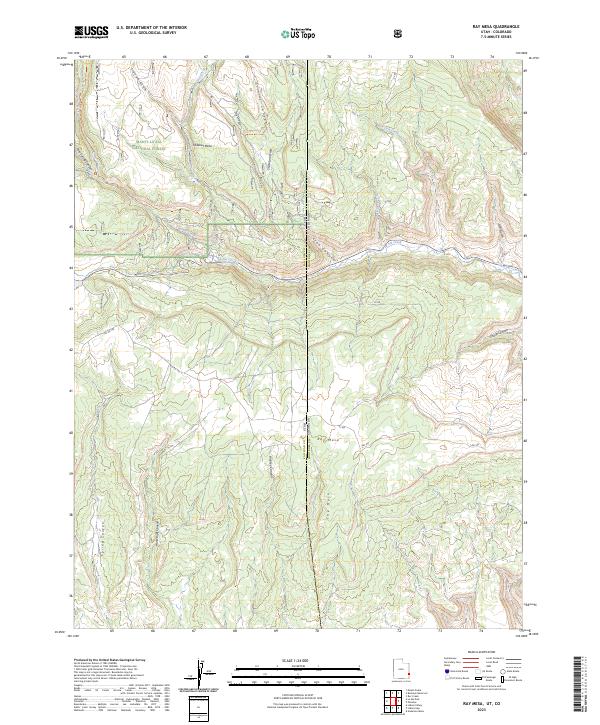
2023 Map of Ray Mesa
USGS Topo · Published 2023About this map
The Manti-La Sal National Forest dominates the western portion of this 2023 survey, where high plateau terrain drops sharply into a complex system of drainage canyons. This arid borderland where Utah meets Colorado is defined by prominent topographical landmarks like Hideout Mesa and Ray Mesa, which serve as natural anchors for the surrounding landscape. The drainage patterns of La Sal Creek and Lion Creek flow eastward across the state line, carving deep relief into the mesas. Local connectivity is maintained through a network of forest and county routes including Buckeye Rd and Woodland Rd, while primitive paths like the Lower Two-Mile Trl and Trinity Canyon Trl penetrate the more difficult terrain. This map provides a detailed view of the remote canyon country south of the La Sal Mountains, illustrating the intersection of national forest management and the high-desert border geography.
Find a feature on this map
40 named features on this map. Tap any name to fly to it.
Don’t see what you’re looking for? This feature index may not catch every label — zoom into the map to look around manually.
Map Details
Editions of this 2023 Ray Mesa Map
This is the sole edition of this map. No revisions or reprints were ever made.
Other maps of this area

1885 · La Sal
USGS Topo · 1:250,000

1916 · Paradox Valley
USGS Topo · 1:125,000

1922 · Paradox Valley
USGS Topo · 1:125,000

1948 · Roc Creek
USGS Topo · 1:24,000

1948 · Paradox
USGS Topo · 1:24,000

1949 · Paradox
USGS Topo · 1:24,000

1949 · Roc Creek
USGS Topo · 1:24,000
1949 · Anderson Mesa
USGS Topo · 1:24,000
1950 · Anderson Mesa
USGS Topo · 1:24,000

1954 · Mt Peale 1 SE
USGS Topo · 1:24,000