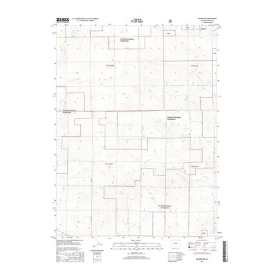
2016 Map of Raymer NW
USGS Topo · Published 2016About this map
Pawnee National Grassland dominates this corner of Weld County, showing a landscape defined by expansive public rangelands and the sparse infrastructure of the high plains. The terrain is marked by the intermittent drainage of Wild Horse Cr and the presence of Bringleson Reservoir, reflecting the critical importance of water management in this arid region. The map preserves the geometric precision of the Public Land Survey System, with section lines and rural routes like CO Rd 115 and CO Rd 104 providing the primary navigational grid across the grasslands. This 2016 record illustrates the intersection of federal land management and local agricultural utility, where the vast open spaces of the Png are punctuated only by essential transport corridors and isolated water sources.
Find a feature on this map
10 named features on this map. Tap any name to fly to it.
Don’t see what you’re looking for? This feature index may not catch every label — zoom into the map to look around manually.
Map Details
Editions of this 2016 Raymer NW Map
This is the sole edition of this map. No revisions or reprints were ever made.
Other maps of this area

1954 · Sterling
USGS Topo · 1:250,000

1954 · Greeley
USGS Topo · 1:250,000

1957 · Greeley
USGS Topo · 1:250,000

1958 · Greeley
USGS Topo · 1:250,000

1958 · Sterling
USGS Topo · 1:250,000

1961 · Greeley
USGS Topo · 1:250,000

1964 · Greeley
USGS Topo · 1:250,000

1965 · Greeley
USGS Topo · 1:250,000
1972 · Keota SE
USGS Topo · 1:24,000
1972 · Keota
USGS Topo · 1:24,000