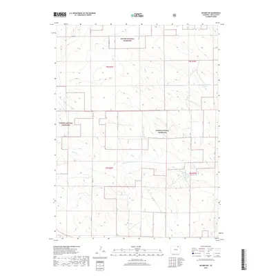
2019 Map of Raymer NW
USGS Topo · Published 2019About this map
Pawnee National Grassland dominates this corner of Weld County, preserving a landscape of shortgrass prairie as it appeared in 2019. The terrain is defined by the intermittent drainage of Wild Horse Cr, which winds across the southern half of the quadrangle. Human intervention in this arid environment is most evident in the Bringleson Reservoir to the northeast and the stark, grid-like progression of section lines and county roads. A network of rural routes, including Co Rd 104 and Co Rd 115, provides the primary framework for navigating the expansive grasslands. The survey reflects the enduring Public Land Survey System structure, with Township and Range boundaries like t9n r59w and t8n r58w neatly dividing the open range and scattered water features.
Find a feature on this map
9 named features on this map. Tap any name to fly to it.
Don’t see what you’re looking for? This feature index may not catch every label — zoom into the map to look around manually.
Map Details
Editions of this 2019 Raymer NW Map
This is the sole edition of this map. No revisions or reprints were ever made.
Other maps of this area

1954 · Sterling
USGS Topo · 1:250,000

1954 · Greeley
USGS Topo · 1:250,000

1957 · Greeley
USGS Topo · 1:250,000

1958 · Greeley
USGS Topo · 1:250,000

1958 · Sterling
USGS Topo · 1:250,000

1961 · Greeley
USGS Topo · 1:250,000

1964 · Greeley
USGS Topo · 1:250,000

1965 · Greeley
USGS Topo · 1:250,000
1972 · Keota SE
USGS Topo · 1:24,000
1972 · Keota
USGS Topo · 1:24,000