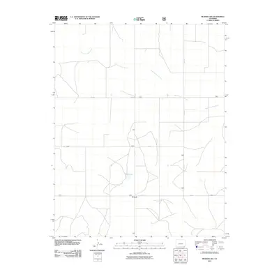
2011 Map of Reader Lake
USGS Topo · Published 2011About this map
Kirkwell stands as the primary point of interest in this high-plains landscape of southeastern Colorado. This 2011 survey reveals a section of the county defined by its ephemeral hydrology and a rigid grid of rural transport. The local geography is shaped by the wandering courses of the South Fork Sand Arroyo and the North Fork Sand Arroyo, which drain the open country toward the east. Centrally located, Reader Lake provides a rare water feature in an area otherwise characterized by these seasonal arroyos and long stretches of section roads like Co Rd R and Co Rd 10. The map illustrates the sparse settlement pattern typical of the region, where the intersection of these routes at Kirkwell serves as the small hub for the surrounding agricultural or ranching landscape.
Find a feature on this map
10 named features on this map. Tap any name to fly to it.
Don’t see what you’re looking for? This feature index may not catch every label — zoom into the map to look around manually.
Map Details
Editions of this 2011 Reader Lake Map
This is the sole edition of this map. No revisions or reprints were ever made.
Other maps of this area

1891 · Springfield
USGS Topo · 1:125,000

1892 · Mt Carrizo
USGS Topo · 1:125,000

1893 · Springfield
USGS Topo · 1:125,000

1955 · La Junta
USGS Topo · 1:250,000

1958 · La Junta
USGS Topo · 1:250,000

1968 · La Junta
USGS Topo · 1:250,000

1978 · Edler
USGS Topo · 1:24,000
1978 · Furnish Canyon East
USGS Topo · 1:24,000

1978 · Pritchett
USGS Topo · 1:24,000

1978 · Utleyville
USGS Topo · 1:24,000