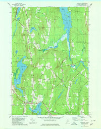
1980 Map of Readfield
USGS Topo · Published 1980About this map
The town of Readfield serves as a central hub in this Kennebec County landscape, where the Maine Central railroad tracks pass through Readfield Depot. The area is defined by its abundant water bodies, including the irregular shorelines of Torsey Lake and Maranacook Lake, which provided the base for local development and recreation. Moving north, the terrain rises toward Hornbeam Mtn and Bowen Hill, where smaller settlements like Locks Corner and East Mt Vernon are connected by a network of rural roads such as Cobbs Hill Road and Wings Mills Road.
Find a feature on this map
71 named features on this map. Tap any name to fly to it.
Don’t see what you’re looking for? This feature index may not catch every label — zoom into the map to look around manually.
Map Details
Editions of this 1980 Readfield Map
This is the sole edition of this map. No revisions or reprints were ever made.
Other maps of this area

1892 · Augusta
USGS Topo · 1:62,500

1894 · Norridgewock
USGS Topo · 1:62,500

1898 · Norridgewock
USGS Topo · 1:62,500

1910 · Livermore
USGS Topo · 1:62,500

1912 · Livermore
USGS Topo · 1:62,500

1924 · Farmington
USGS Topo · 1:62,500

1941 · Livermore
USGS Topo · 1:62,500

1941 · Augusta
USGS Topo · 1:62,500

1943 · Augusta
USGS Topo · 1:62,500

1943 · Norridgewock
USGS Topo · 1:62,500