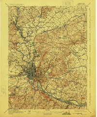
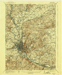
1915 Map of Reading
USGS Topo · Published 1924About this map
The Schuylkill River and its parallel Schuylkill Canal anchor this early 20th-century view of a bustling industrial and agricultural hub. The city of Reading is depicted with its dense urban grid, flanked by the prominent Neversink Mountain and the leisure grounds of Carsonia Park. Beyond the city center, the landscape is a patchwork of township life, where traditional industry at Oley Furnace and Stony Creek Mills coexists with a maturing transport network. The presence of the Allentown and Reading Electric Railway alongside the Philadelphia and Reading Railroad reflects a moment of peak connectivity between satellite settlements like Friedensburg and Fleetwood. Genealogists can identify dozens of named schools and rural congregations, including the Gernant Church and Friends Meetinghouse, which served the region's diverse Quaker and Pennsylvania German communities.
Find a feature on this map
164 named features on this map. Tap any name to fly to it.
Don’t see what you’re looking for? This feature index may not catch every label — zoom into the map to look around manually.
Map Details
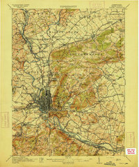
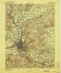
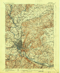
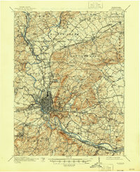
Editions of this 1915 Reading Map
6 editions found
Other maps of this area

1889 · Pottsville
USGS Topo · 1:62,500

1891 · Pottsville
USGS Topo · 1:62,500

1894 · Reading
USGS Topo · 1:62,500

1902 · Boyertown
USGS Topo · 1:62,500

1902 · Wernersville
USGS Topo · 1:62,500

1902 · Slatington
USGS Topo · 1:62,500

1905 · Honey Brook
USGS Topo · 1:62,500

1906 · Phoenixville
USGS Topo · 1:62,500

1906 · New Holland
USGS Topo · 1:62,500

1907 · Honeybrook
USGS Topo · 1:62,500