1946 Map of Reading
USGS Topo · Published 1946About this map
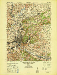
The Schuylkill River carves a winding path through the heart of Berks County, anchoring a landscape that was rapidly industrializing during the mid-1940s. Centered on the city of Reading, this map captures the dense urban core and its surrounding boroughs, from the planned community of Wyomissing to the smaller milling settlements of Mohnton and Gibraltar. The presence of the Reading railroad network and the Fairgrounds north of the city center illustrates the area's role as a regional hub for commerce and entertainment.
Find a feature on this map
138 named features on this map. Tap any name to fly to it.
Don’t see what you’re looking for? This feature index may not catch every label — zoom into the map to look around manually.
Map Details
Editions of this 1946 Reading Map
This is the sole edition of this map. No revisions or reprints were ever made.
Other maps of this area

1889 · Pottsville
USGS Topo · 1:62,500

1891 · Pottsville
USGS Topo · 1:62,500

1894 · Reading
USGS Topo · 1:62,500

1902 · Boyertown
USGS Topo · 1:62,500

1902 · Wernersville
USGS Topo · 1:62,500

1902 · Slatington
USGS Topo · 1:62,500

1905 · Honey Brook
USGS Topo · 1:62,500

1906 · Phoenixville
USGS Topo · 1:62,500

1906 · New Holland
USGS Topo · 1:62,500

1907 · Honeybrook
USGS Topo · 1:62,500