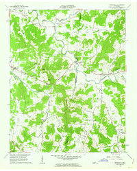
1962 Map of Readyville
USGS Topo · Published 1963About this map
Readyville sits at the crossing of the East Fork Stones River along the border of Rutherford and Cannon Counties, serving as a focal point for a landscape defined by winding watercourses and prominent knobs. In the early 1960s, this area maintained a traditional rural structure, with community life centered around small settlements like Kittrell, Burt, and Halls Hill. The map documents a significant network of country churches, including Antioch Ch, Hickory Grove Ch, and New Hope Ch, alongside local schools such as Science Hill Sch and South Side Sch.
Find a feature on this map
38 named features on this map. Tap any name to fly to it.
Don’t see what you’re looking for? This feature index may not catch every label — zoom into the map to look around manually.
Map Details
Editions of this 1962 Readyville Map
3 editions found
Other maps of this area

1908 · Woodbury
USGS Topo · 1:62,500

1913 · Hollow Springs
USGS Topo · 1:62,500

1916 · Murfreesboro
USGS Topo · 1:62,500

1936 · Webbs Jungle
USGS Topo · 1:24,000

1936 · Beech Grove
USGS Topo · 1:24,000

1936 · Petty Gap
USGS Topo · 1:24,000

1942 · Statesville
USGS Topo · 1:100,000

1942 · Lebanon
USGS Topo · 1:100,000

1943 · Mc Minnville
USGS Topo · 1:100,000

1944 · Shelbyville
USGS Topo · 1:100,000