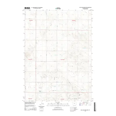
2015 Map of Red Cloud Creek West
USGS Topo · Published 2015About this map
Oregon Trl cuts across this high-plains landscape, marking the enduring path of historic westward migration through Goshen County. The terrain is defined by a series of drainage patterns and seasonal waterways, including Red Cloud Cr and Dry Rawhide Cr, which flow through the northern and central sections of the survey. In the southern portion, the elevation rises toward Pine Ridge, where Pine Ridge Cr and Spring Canyon shape the local topography. This 2015 USGS survey documents a mix of named ranch roads and rural boulevards, such as Bandemer Blvd and Buffalo Blvd, framing the Skinner Reservoir. The map provides a clear look at the land division and natural landmarks like Dickerson Draw and Willy Draw in a part of Wyoming still closely tied to its ranching and pioneer roots.
Find a feature on this map
31 named features on this map. Tap any name to fly to it.
Don’t see what you’re looking for? This feature index may not catch every label — zoom into the map to look around manually.
Map Details
Editions of this 2015 Red Cloud Creek West Map
This is the sole edition of this map. No revisions or reprints were ever made.
Other maps of this area

1896 · Patrick
USGS Topo · 1:125,000

1896 · Hartville
USGS Topo · 1:125,000

1901 · Hartville
USGS Topo · 1:125,000

1950 · Casebier Hill
USGS Topo · 1:24,000

1950 · Fort Laramie
USGS Topo · 1:24,000

1951 · Moore Spring
USGS Topo · 1:24,000

1952 · Fort Laramie
USGS Topo · 1:24,000

1954 · Torrington
USGS Topo · 1:250,000

1958 · Torrington
USGS Topo · 1:250,000
1960 · Barnes
USGS Topo · 1:24,000