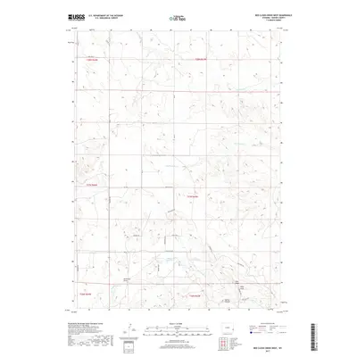
2017 Map of Red Cloud Creek West
USGS Topo · Published 2017About this map
Oregon Trl cuts across the center of this Wyoming landscape, marking a historic corridor of western expansion through northern Goshen County. The terrain is defined by the significant rise of Pine Ridge, which serves as a topographic anchor in the southeastern section, overseeing the seasonal drainage systems of Pine Ridge Cr and Willy Draw. Agricultural and ranching interests are evident in the management of local water resources, notably at the Skinner Reservoir and along the winding courses of Red Cloud Cr and Dry Rawhide Cr. The modern road network, including names like Buffalo Blvd and Cowboy Way, overlays an older geography of draws and canyons, such as Dickerson Draw and Spring Canyon. This 2017 survey illustrates how legacy trails and natural landmarks continue to shape the rural development of the High Plains.
Find a feature on this map
31 named features on this map. Tap any name to fly to it.
Don’t see what you’re looking for? This feature index may not catch every label — zoom into the map to look around manually.
Map Details
Editions of this 2017 Red Cloud Creek West Map
This is the sole edition of this map. No revisions or reprints were ever made.
Other maps of this area

1896 · Patrick
USGS Topo · 1:125,000

1896 · Hartville
USGS Topo · 1:125,000

1901 · Hartville
USGS Topo · 1:125,000

1950 · Casebier Hill
USGS Topo · 1:24,000

1950 · Fort Laramie
USGS Topo · 1:24,000

1951 · Moore Spring
USGS Topo · 1:24,000

1952 · Fort Laramie
USGS Topo · 1:24,000

1954 · Torrington
USGS Topo · 1:250,000

1958 · Torrington
USGS Topo · 1:250,000
1960 · Barnes
USGS Topo · 1:24,000