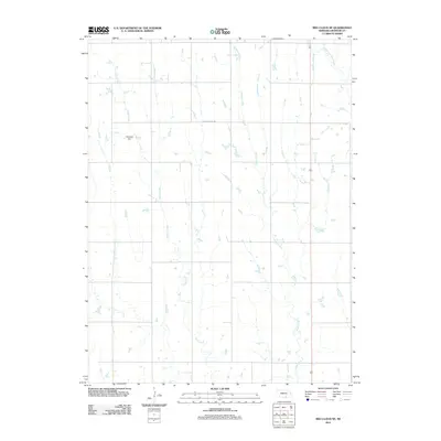
2011 Map of Red Cloud NE
USGS Topo · Published 2011About this map
Indian Creek and Crooked Creek define the vertical grain of this Webster County landscape, flowing north-to-south across a grid of section lines and rural thoroughfares. The terrain is largely defined by these drainage patterns, where small tributaries feed into the larger creek beds that carve through the Nebraska plains. Water management and land use are visible through features like the Niemeyer Dam, which suggests a localized focus on irrigation or livestock support within this agricultural area. In the northeast corner, the West Fork Elm Creek adds to the network of watercourses, while W Powerline Rd serves as one of the few named landmarks slicing across the prevailing north-south orientation of the local infrastructure. This survey provides a clear look at the intersection of natural hydrology and the persistent rectangular survey system used to organize the American West.
Find a feature on this map
5 named features on this map. Tap any name to fly to it.
Don’t see what you’re looking for? This feature index may not catch every label — zoom into the map to look around manually.
Map Details
Editions of this 2011 Red Cloud NE Map
This is the sole edition of this map. No revisions or reprints were ever made.
Other maps of this area

1897 · Red Cloud
USGS Topo · 1:125,000

1898 · Superior
USGS Topo · 1:125,000

1940 · Red Cloud
USGS Topo · 1:62,500

1942 · Red Cloud
USGS Topo · 1:62,500

1955 · Grand Island
USGS Topo · 1:250,000

1957 · Grand Island
USGS Topo · 1:250,000

1958 · Grand Island
USGS Topo · 1:250,000

1969 · Blue Hill
USGS Topo · 1:24,000
1969 · Campbell
USGS Topo · 1:24,000
1969 · Bladen
USGS Topo · 1:24,000