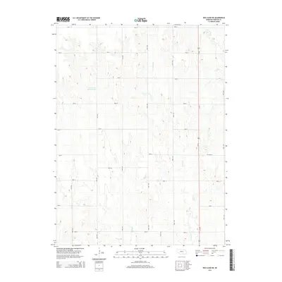
2014 Map of Red Cloud NE
USGS Topo · Published 2014About this map
Niemeyer Reservoir sits at the heart of this Webster County landscape, a vital water source in an area defined by its systematic agricultural grid. The terrain is marked by the north-south drainages of Indian Cr and Crooked Cr, which carve through the plains and dictate the local topography. This 2014 survey illustrates the modern rural infrastructure of south-central Nebraska, where the rigid section line road system—represented by routes like Road 1000 and Road Q—interfaces with regional transit corridors. The prominent north-south transit of Us-281 connects this agricultural interior to larger markets, while the specialized Ne-91b-Spur provides a targeted link within the local transportation network. To the northeast, the headwaters of W Fork Elm Cr further define the drainage patterns of this high plains environment.
Find a feature on this map
23 named features on this map. Tap any name to fly to it.
Don’t see what you’re looking for? This feature index may not catch every label — zoom into the map to look around manually.
Map Details
Editions of this 2014 Red Cloud NE Map
This is the sole edition of this map. No revisions or reprints were ever made.
Other maps of this area

1897 · Red Cloud
USGS Topo · 1:125,000

1898 · Superior
USGS Topo · 1:125,000

1940 · Red Cloud
USGS Topo · 1:62,500

1942 · Red Cloud
USGS Topo · 1:62,500

1955 · Grand Island
USGS Topo · 1:250,000

1957 · Grand Island
USGS Topo · 1:250,000

1958 · Grand Island
USGS Topo · 1:250,000

1969 · Blue Hill
USGS Topo · 1:24,000
1969 · Campbell
USGS Topo · 1:24,000
1969 · Bladen
USGS Topo · 1:24,000