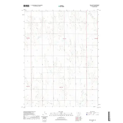
2017 Map of Red Cloud NE
USGS Topo · Published 2017About this map
Indian Cr and Crooked Cr carve a series of north-south drainage patterns across this rural Webster County landscape. The topography is defined by the agricultural grid of the Public Land Survey System, with gravel roads like RD N and RD 900 following section lines through the interior. A notable landmark in the northwestern portion of the map is Niemeyer Reservoir, a small body of water situated among the draws of Indian Cr. The northeastern corner is crossed by the headwaters of W Fork Elm Cr, illustrating the subtle continental divide between local creek systems. This 2017 survey shows a region deeply rooted in a traditional section-line road network that has persisted for generations, providing a clear view of the farm-to-market infrastructure in south-central Nebraska.
Find a feature on this map
20 named features on this map. Tap any name to fly to it.
Don’t see what you’re looking for? This feature index may not catch every label — zoom into the map to look around manually.
Map Details
Editions of this 2017 Red Cloud NE Map
This is the sole edition of this map. No revisions or reprints were ever made.
Other maps of this area

1897 · Red Cloud
USGS Topo · 1:125,000

1898 · Superior
USGS Topo · 1:125,000

1940 · Red Cloud
USGS Topo · 1:62,500

1942 · Red Cloud
USGS Topo · 1:62,500

1955 · Grand Island
USGS Topo · 1:250,000

1957 · Grand Island
USGS Topo · 1:250,000

1958 · Grand Island
USGS Topo · 1:250,000

1969 · Blue Hill
USGS Topo · 1:24,000
1969 · Campbell
USGS Topo · 1:24,000
1969 · Bladen
USGS Topo · 1:24,000