
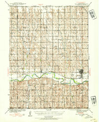
1940 Map of Red Cloud
USGS Topo · Published 1954About this map
Red Cloud stands as the primary hub along the Republican River in this detailed survey from the late 1930s. The landscape is defined by a dense grid of rural education and community life, featuring dozens of localized schoolhouses such as North Star Sch, Poor Farm Sch, and Sunnyside Sch. The Chicago Burlington and Quincy railroad parallels the river valley, connecting the town to Inavale and providing the essential transport link for this agricultural region. Evidence of early Nebraska settlement is visible through numerous family and community landmarks, including the Catherton Cem and New Virginia Cem. The southern portion of the map transitions into the rolling hills of Walnut Creek and the state line, where the topography is dissected by many small drainages like Penny Creek and Lost Creek.
Find a feature on this map
59 named features on this map. Tap any name to fly to it.
Don’t see what you’re looking for? This feature index may not catch every label — zoom into the map to look around manually.
Map Details
Editions of this 1940 Red Cloud Map
2 editions found
Other maps of this area

1893 · Smith Center
USGS Topo · 1:125,000

1894 · Mankato
USGS Topo · 1:125,000

1897 · Red Cloud
USGS Topo · 1:125,000

1898 · Superior
USGS Topo · 1:125,000

1942 · Red Cloud
USGS Topo · 1:62,500

1955 · Grand Island
USGS Topo · 1:250,000

1955 · Beloit
USGS Topo · 1:250,000

1957 · Grand Island
USGS Topo · 1:250,000

1958 · Grand Island
USGS Topo · 1:250,000

1959 · Beloit
USGS Topo · 1:250,000