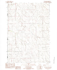
1982 Map of Red Elm SW
USGS Topo · Published 1983About this map
The Cheyenne River Indian Res Bdy marks the northern extent of this landscape, where the prairie topography is defined by the branching drainage of Flint Rock Creek. The map documents a period of transition in the late twentieth century, showing an environment largely dominated by natural drainage patterns including Rock Creek and the meandering South Fork Flint Rock Creek. Human activity is sparse, evidenced primarily by a singular Water Well and sections of road marked as Abandoned, reflecting the shifting land use and settlement patterns within Ziebach County and neighboring Meade and Perkins counties. This provisional survey provides a snapshot of the region's hydrography before significant modern development, preserving the exact alignment of tribal and county boundaries as they stood in the early 1980s.
Find a feature on this map
8 named features on this map. Tap any name to fly to it.
Don’t see what you’re looking for? This feature index may not catch every label — zoom into the map to look around manually.
Map Details
Editions of this 1982 Red Elm SW Map
This is the sole edition of this map. No revisions or reprints were ever made.
Other maps of this area

1951 · Redelm NE
USGS Topo · 1:24,000

1951 · Redelm NW
USGS Topo · 1:24,000

1951 · Faith NE
USGS Topo · 1:24,000

1953 · Rapid City
USGS Topo · 1:250,000

1953 · McIntosh
USGS Topo · 1:250,000

1954 · Lemmon
USGS Topo · 1:250,000

1954 · Pierre
USGS Topo · 1:250,000

1957 · Lemmon
USGS Topo · 1:250,000

1957 · Rapid City
USGS Topo · 1:250,000

1958 · Pierre
USGS Topo · 1:250,000