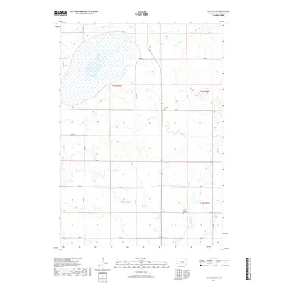
2017 Map of Red Lake East
USGS Topo · Published 2017About this map
Red Lake dominates the northwest quadrant of this Brule County landscape, where the prairie gives way to a network of seasonal drainages and local roads. The section-line grid is clearly defined by routes such as 348th Ave and 254th St, illustrating the enduring township-and-range survey system. In the southern reaches of the map, Nelson Cr meanders through the terrain toward Panzour Dam, which controls the local drainage north of the 43.6250° latitude. Genealogical interest is anchored by two established burial sites: the Lutheran Cem located near the center of the quadrangle and the Saint Procopius Church Cem situated further south. These landmarks, along with Reither Cr in the west, reflect a rural community structure centered around small water resources and parish life near Hwy 50.
Find a feature on this map
26 named features on this map. Tap any name to fly to it.
Don’t see what you’re looking for? This feature index may not catch every label — zoom into the map to look around manually.
Map Details
Editions of this 2017 Red Lake East Map
This is the sole edition of this map. No revisions or reprints were ever made.
Other maps of this area

1935 · Chamberlain
USGS Topo · 1:62,500

1939 · Chamberlain
USGS Topo · 1:62,500

1940 · Iona
USGS Topo · 1:62,500

1941 · Pukwana
USGS Topo · 1:62,500

1944 · Iona
USGS Topo · 1:62,500

1951 · Pukwana
USGS Topo · 1:62,500

1955 · Mitchell
USGS Topo · 1:250,000

1959 · Mitchell
USGS Topo · 1:250,000
1974 · Bond Bottom
USGS Topo · 1:24,000

1974 · Red Lake West
USGS Topo · 1:24,000