
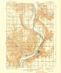
1939 Map of Chamberlain
USGS Topo · Published 1939About this map
Chamberlain and Oacoma anchor this 1930s landscape where the Missouri River carves a wide path through central South Dakota. The topography reveals a pre-dam era river system, featuring prominent landforms like American Island and Bice Island before major mid-century Missouri River basin projects altered the shoreline. On the east bank, the town of Chamberlain serves as a hub for the Chicago Milwaukee St Paul and Pacific railroad, while the west bank is dominated by the expansive Lower Brule Indian Reservation. Local civic life is documented through numerous rural schoolhouses, such as Prairie Star Sch and Hanson Sch, alongside the C C C Camp and Grace Mission. The confluence with the White River in the south provides a geographic marker of the transition into the Iona region.
Find a feature on this map
32 named features on this map. Tap any name to fly to it.
Don’t see what you’re looking for? This feature index may not catch every label — zoom into the map to look around manually.
Map Details
Editions of this 1939 Chamberlain Map
2 editions found
Other maps of this area

1935 · Chamberlain
USGS Topo · 1:62,500

1940 · Iona
USGS Topo · 1:62,500

1941 · Pukwana
USGS Topo · 1:62,500

1944 · Iona
USGS Topo · 1:62,500

1951 · Pukwana
USGS Topo · 1:62,500

1952 · Reliance SE
USGS Topo · 1:24,000

1952 · Hamill NE
USGS Topo · 1:24,000

1952 · Oacoma
USGS Topo · 1:24,000

1952 · Iona NW
USGS Topo · 1:24,000

1953 · Huron
USGS Topo · 1:250,000