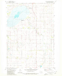
1979 Map of Red Lake East
USGS Topo · Published 1980About this map
Red Lake and its surrounding wetlands dominate this 1970s landscape in Brule County, serving as a focal point for conservation and local recreation within the Red Lake State Public Shooting Area. The prairie terrain is structured by a grid of rural roads and section lines, with drainage provided by the meandering Nelson Creek and Reimer Creek. The map documents a sparsely populated agricultural region where social life centered on institutions like the Red Lake Sch and Ola Sch, alongside traditional religious sites such as the St Procopius Ch Cem and the Lutheran Cem. Small-scale industrial activity is evidenced by scattered Gravel Pits, while water management is highlighted by the presence of a Flowing Well and the southern Panzour Dam. This survey reflects the late-twentieth-century rural character of the South Dakota plains, preserving the locations of namesake schools and cemeteries essential for genealogical research.
Find a feature on this map
19 named features on this map. Tap any name to fly to it.
Don’t see what you’re looking for? This feature index may not catch every label — zoom into the map to look around manually.
Map Details
Editions of this 1979 Red Lake East Map
This is the sole edition of this map. No revisions or reprints were ever made.
Other maps of this area

1935 · Chamberlain
USGS Topo · 1:62,500

1939 · Chamberlain
USGS Topo · 1:62,500

1940 · Iona
USGS Topo · 1:62,500

1941 · Pukwana
USGS Topo · 1:62,500

1944 · Iona
USGS Topo · 1:62,500

1951 · Pukwana
USGS Topo · 1:62,500

1955 · Mitchell
USGS Topo · 1:250,000

1959 · Mitchell
USGS Topo · 1:250,000
1974 · Bond Bottom
USGS Topo · 1:24,000

1974 · Red Lake West
USGS Topo · 1:24,000