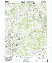
1999 Map of Red Lion
USGS Topo · Published 2002About this map
Red Lion serves as a primary hub of development in this South Central Pennsylvania landscape, where early industrial sites and rural crossroads communities define the local geography. Significant historical industry is evidenced by Margaretta Furnace and Leiphart Mill, while the high ground of Mt Pisgah and the expansive Samuel S Lewis State Park overlook the winding course of Canadochly Creek. The map documents a dense network of country schools and houses of worship, including Mazie Gable Sch and Bethlehem Ch, which anchored the social life of surrounding hamlets like Grimms Crossroads and Bittersville. Technological infrastructure, such as the Western Union Relay Tower and several radio towers, appears alongside traditional family-named landmarks and cemeteries like Oleweiler Cem, marking the intersection of modern telecommunications with the area's deep-rooted agrarian and early industrial foundations.
Find a feature on this map
59 named features on this map. Tap any name to fly to it.
Don’t see what you’re looking for? This feature index may not catch every label — zoom into the map to look around manually.
Map Details
Editions of this 1999 Red Lion Map
This is the sole edition of this map. No revisions or reprints were ever made.
Other maps of this area

1902 · Lancaster
USGS Topo · 1:62,500

1904 · Lancaster
USGS Topo · 1:62,500

1908 · Middletown
USGS Topo · 1:62,500

1908 · York
USGS Topo · 1:62,500

1910 · York
USGS Topo · 1:62,500

1912 · Mc Calls Ferry
USGS Topo · 1:62,500

1943 · Lancaster
USGS Topo · 1:62,500

1943 · Middletown
USGS Topo · 1:62,500

1943 · Mc Calls Ferry
USGS Topo · 1:62,500

1948 · Baltimore
USGS Topo · 1:250,000