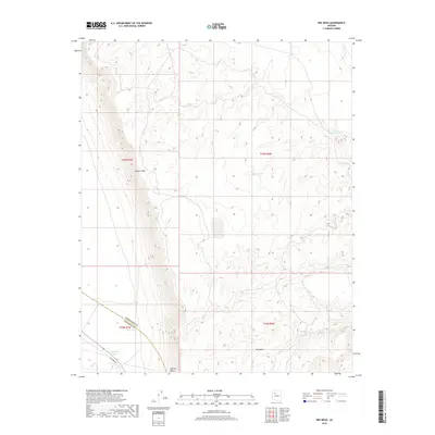
2018 Map of Red Mesa
USGS Topo · Published 2018About this map
The Aubrey Cliffs dominate this high-desert landscape in Yavapai and Coconino counties, forming a dramatic escarpment that separates the elevated plateau from the lower reaches of Aubrey Valley. This 2018 survey documents a remote ranching and grazing environment where water management is the primary human imprint on the land. Named stock tanks, such as Black Mountain Tank, Burro Tank, and Caterpillar Tank, are strategically positioned across the terrain to support livestock in an otherwise arid region. In the southwestern corner, the presence of Railroad Ave suggests a corridor for transportation and utility access, while the broad expanse of Chino Wash in the northeast serves as the principal drainage for the surrounding heights, including the namesake Red Mesa.
Find a feature on this map
15 named features on this map. Tap any name to fly to it.
Don’t see what you’re looking for? This feature index may not catch every label — zoom into the map to look around manually.
Map Details
Editions of this 2018 Red Mesa Map
This is the sole edition of this map. No revisions or reprints were ever made.
Other maps of this area

1886 · Diamond Creek
USGS Topo · 1:250,000

1886 · Chino
USGS Topo · 1:250,000

1891 · Chino
USGS Topo · 1:250,000

1892 · Diamond Creek
USGS Topo · 1:250,000

1948 · Williams
USGS Topo · 1:250,000

1954 · Williams
USGS Topo · 1:250,000

1956 · Williams
USGS Topo · 1:250,000

1960 · Williams
USGS Topo · 1:250,000

1961 · Williams
USGS Topo · 1:250,000
1980 · Audley
USGS Topo · 1:24,000