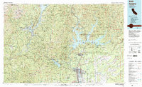
1984 Map of Redding
USGS Topo · Published 1984About this map
The Shasta Dam dominates this 1984 survey, holding back the massive waters of Shasta Lake where the McCloud River, Pit River, and Sacramento River converge. This industrial and recreational landscape is defined by massive water management projects and a legacy of hard-rock mining. To the west, the Whiskeytown Unit and the Trinity National Forest provide a stark contrast to the growing urban centers of Redding, Enterprise, and Central Valley.
Find a feature on this map
99 named features on this map. Tap any name to fly to it.
Don’t see what you’re looking for? This feature index may not catch every label — zoom into the map to look around manually.
Map Details
Editions of this 1984 Redding Map
2 editions found
Other maps of this area

1886 · Lassen Peak
USGS Topo · 1:250,000

1886 · Modoc Lava Bed
USGS Topo · 1:250,000

1886 · Shasta
USGS Topo · 1:250,000

1890 · Red Bluff
USGS Topo · 1:250,000

1892 · Modoc Lava-Bed
USGS Topo · 1:250,000

1892 · Lassen Peak
USGS Topo · 1:250,000

1894 · Lassen Peak
USGS Topo · 1:250,000

1894 · Red Bluff
USGS Topo · 1:250,000

1894 · Shasta
USGS Topo · 1:250,000

1901 · Redding
USGS Topo · 1:125,000