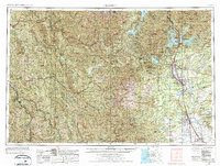
1958 Map of Redding
USGS Topo · Published 1977About this map
The Sacramento River corridor serves as the primary artery of development in this Northern California survey, which was field-checked in the late 1950s and updated with 1970s aerial data. The expansion of Redding and Enterprise is clearly visible against the backdrop of massive federal water projects, including Shasta Lake and the Whiskeytown Lake and Clair Engle Lake reservoirs. These massive impoundments transformed the landscape of the Shasta National Forest and Trinity National Forest, submerging older topography to provide power and irrigation. Away from the river valley, the terrain rises into the Trinity Alps and the Yolla Bolly Mountains. The Southern Pacific railroad remains a critical link for timber and agricultural transport through settlements like Anderson, Cottonwood, and Red Bluff. Smaller mountain communities such as Weaverville and Hayfork remain hubs for the region's interior reaches, connected by winding routes like Highway 299.
Find a feature on this map
156 named features on this map. Tap any name to fly to it.
Don’t see what you’re looking for? This feature index may not catch every label — zoom into the map to look around manually.
Map Details
Editions of this 1958 Redding Map
5 editions found

Other maps of this area

1886 · Lassen Peak
USGS Topo · 1:250,000

1886 · Modoc Lava Bed
USGS Topo · 1:250,000

1886 · Shasta
USGS Topo · 1:250,000

1890 · Red Bluff
USGS Topo · 1:250,000

1891 · Chico
USGS Topo · 1:125,000

1892 · Modoc Lava-Bed
USGS Topo · 1:250,000

1892 · Lassen Peak
USGS Topo · 1:250,000

1893 · Chico
USGS Topo · 1:125,000

1894 · Lassen Peak
USGS Topo · 1:250,000

1894 · Red Bluff
USGS Topo · 1:250,000