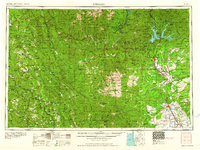
1958 Map of Redding
USGS Topo · Published 1960About this map
The Sacramento River and the newly developed Shasta Reservoir form the central axis of this northern California landscape during the late 1950s. While the valley floor is defined by the growing hubs of Redding and Red Bluff, the surrounding terrain is dominated by massive protected lands, including Six Rivers National Forest and Trinity National Forest. The transition from the agriculture-rich valley to the high peaks of the Trinity Alps and Yolla Bolly Mountains is bridged by historic mining and logging outposts like French Gulch and Weaverville. Transport networks are well-established here, with U S 99 following the river and the Southern Pacific RR providing critical rail links for the region's timber and trade. To the west, the Northwestern Pacific RR serves the redwood corridor near Garberville and Humboldt Redwoods State Park, illustrating the complex logistical demands of this diverse geography.
Find a feature on this map
182 named features on this map. Tap any name to fly to it.
Don’t see what you’re looking for? This feature index may not catch every label — zoom into the map to look around manually.
Map Details
Editions of this 1958 Redding Map
5 editions found

Other maps of this area

1886 · Lassen Peak
USGS Topo · 1:250,000

1886 · Modoc Lava Bed
USGS Topo · 1:250,000

1886 · Shasta
USGS Topo · 1:250,000

1890 · Red Bluff
USGS Topo · 1:250,000

1891 · Chico
USGS Topo · 1:125,000

1892 · Modoc Lava-Bed
USGS Topo · 1:250,000

1892 · Lassen Peak
USGS Topo · 1:250,000

1893 · Chico
USGS Topo · 1:125,000

1894 · Lassen Peak
USGS Topo · 1:250,000

1894 · Red Bluff
USGS Topo · 1:250,000