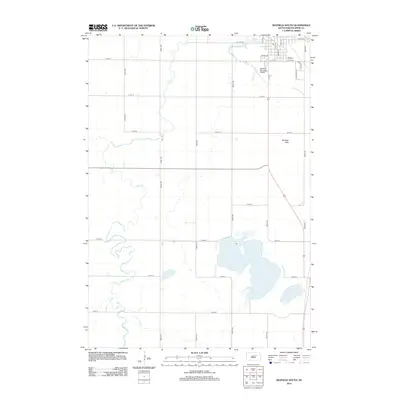
2012 Map of Redfield South
USGS Topo · Published 2012About this map
Lake Louise and the meandering path of Turtle Cr define the rural landscape south of the Redfield town center. In this early 21st-century portrait of Spink County, the transition from the structured street grid of the southern town limits to the expansive agricultural sections is clearly visible. The town's infrastructure extends southward with the Redfield Municipal Airport and prominent thoroughfares like S Main St and Plainview Ave. Further south, the terrain softens into the Redfield Hills and a series of water bodies including Twin Lakes and Mud Lake. This layout illustrates a classic High Plains development pattern, where the township's section lines dictate the road network, even as local geography like the creek beds creates natural breaks in the grid. Researchers can trace the proximity of local landmarks such as Railroad St and Sherry Ln to the surrounding prairie landscape.
Find a feature on this map
31 named features on this map. Tap any name to fly to it.
Don’t see what you’re looking for? This feature index may not catch every label — zoom into the map to look around manually.
Map Details
Editions of this 2012 Redfield South Map
This is the sole edition of this map. No revisions or reprints were ever made.
Other maps of this area

1895 · Byron
USGS Topo · 1:125,000

1899 · Redfield
USGS Topo · 1:125,000

1953 · Redfield North
USGS Topo · 1:24,000

1953 · Ashton
USGS Topo · 1:24,000

1953 · Huron
USGS Topo · 1:250,000

1954 · Huron
USGS Topo · 1:250,000

1966 · Redfield South
USGS Topo · 1:24,000
1966 · Zell
USGS Topo · 1:24,000

1966 · Redfield SW
USGS Topo · 1:24,000

1967 · Frankfort SW
USGS Topo · 1:24,000