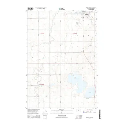
2015 Map of Redfield South
USGS Topo · Published 2015About this map
Redfield anchors the northern edge of this James River Valley landscape, serving as a vital agricultural and transportation hub for the surrounding plains. The town's layout is defined by a dense grid of streets, including S Main St and W 12th Ave, which transition into the long section-line roads characteristic of the Dakota prairie. To the west of the city center, Lake Redfield and the meandering Turtle Creek create a distinct corridor of water and vegetation that breaks the linear geometry of the farmland.
Find a feature on this map
41 named features on this map. Tap any name to fly to it.
Don’t see what you’re looking for? This feature index may not catch every label — zoom into the map to look around manually.
Map Details
Editions of this 2015 Redfield South Map
This is the sole edition of this map. No revisions or reprints were ever made.
Other maps of this area

1895 · Byron
USGS Topo · 1:125,000

1899 · Redfield
USGS Topo · 1:125,000

1953 · Redfield North
USGS Topo · 1:24,000

1953 · Ashton
USGS Topo · 1:24,000

1953 · Huron
USGS Topo · 1:250,000

1954 · Huron
USGS Topo · 1:250,000

1966 · Redfield South
USGS Topo · 1:24,000
1966 · Zell
USGS Topo · 1:24,000

1966 · Redfield SW
USGS Topo · 1:24,000

1967 · Frankfort SW
USGS Topo · 1:24,000