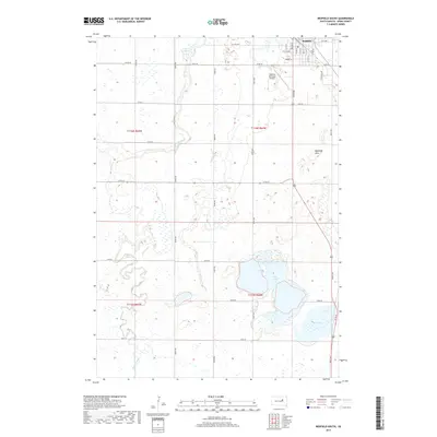
2017 Map of Redfield South
USGS Topo · Published 2017About this map
Redfield occupies the northeastern corner of this Spink County landscape, serving as a hub where the street grid transitions into an expansive network of sectional roads and glacial water bodies. The terrain is defined by the winding course of Turtle Creek, which meanders through the central and southern reaches of the map, carving through the prairie toward Mud Lake. To the south of the city, the Redfield Hills rise above the surrounding plains, providing a distinct geographic break near the Redfield Municipal Airport. This 2017 survey illustrates the persistent agricultural and hydrological patterns of the James River Valley, where significant water features like Lake Redfield, Twin Lakes, and numerous smaller prairie potholes dictate the layout of rural routes like Co Rd 18 and 382nd Ave.
Find a feature on this map
39 named features on this map. Tap any name to fly to it.
Don’t see what you’re looking for? This feature index may not catch every label — zoom into the map to look around manually.
Map Details
Editions of this 2017 Redfield South Map
This is the sole edition of this map. No revisions or reprints were ever made.
Other maps of this area

1895 · Byron
USGS Topo · 1:125,000

1899 · Redfield
USGS Topo · 1:125,000

1953 · Redfield North
USGS Topo · 1:24,000

1953 · Ashton
USGS Topo · 1:24,000

1953 · Huron
USGS Topo · 1:250,000

1954 · Huron
USGS Topo · 1:250,000

1966 · Redfield South
USGS Topo · 1:24,000
1966 · Zell
USGS Topo · 1:24,000

1966 · Redfield SW
USGS Topo · 1:24,000

1967 · Frankfort SW
USGS Topo · 1:24,000