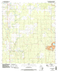
1994 Map of Redhead Branch
USGS Topo · Published 1997About this map
Tulla and the surrounding piney woods of Beauregard Parish are defined by the intricate hydrology of the Redhead Branch drainage system during the mid-1990s. The landscape is marked by a network of seasonal and perennial watercourses, including the winding Barnes Creek, Little Barnes Creek, and the namesake Redhead Branch. This survey, updated from earlier photogrammetry, reveals a rural environment where land use is split between timber tracts and isolated homesteads. The southeastern corner shows evidence of industrial extraction with a large Gravel Pit, providing a contrast to the otherwise agricultural and forested character of the region. The presence of numerous small ponds and cattle tanks suggests the importance of livestock grazing alongside the traditional timber economy that has historically dominated this portion of Louisiana.
Find a feature on this map
1 named feature on this map. Tap any name to fly to it.
Don’t see what you’re looking for? This feature index may not catch every label — zoom into the map to look around manually.
Map Details
Editions of this 1994 Redhead Branch Map
This is the sole edition of this map. No revisions or reprints were ever made.
Other maps of this area

1935 · Longville
USGS Topo · 1:31,680

1947 · DeRidder
USGS Topo · 1:31,680

1947 · Kernan
USGS Topo · 1:31,680

1947 · Ikes
USGS Topo · 1:31,680

1947 · Reeves
USGS Topo · 1:31,680

1947 · Longville
USGS Topo · 1:31,680

1947 · Bundick
USGS Topo · 1:31,680

1947 · Beckwith School
USGS Topo · 1:31,680

1947 · Sugartown
USGS Topo · 1:31,680

1947 · Bannister
USGS Topo · 1:31,680