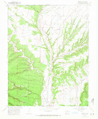
1968 Map of Redmesa
USGS Topo · Published 1972About this map
The Southern Ute Indian Reservation Boundary cuts through the southwestern Colorado landscape, where the La Plata River winds through the high Red Mesa. Small agrarian settlements like Redmesa and Marvel anchor the high ground, connected by rural routes such as Wheeler Dr. The land use of the late 1960s is defined by a sophisticated water management system designed to support agriculture in this arid region, featuring the Pioneer Ditch and Enterprise Ditch. Extensive resource extraction is evident across the quadrangle, with numerous Oil Wells, Gas Wells, and a specific Drill Hole marking the industry of the era. The terrain is deeply incised by drainage systems like Johnson Canyon and Government Draw, while geological landmarks such as South Cinder Butte and Cinder Bluffs stand out in the southeastern corner near the New Mexico border.
Find a feature on this map
43 named features on this map. Tap any name to fly to it.
Don’t see what you’re looking for? This feature index may not catch every label — zoom into the map to look around manually.
Map Details
Editions of this 1968 Redmesa Map
3 editions found
Other maps of this area

1889 · Chaco
USGS Topo · 1:250,000

1892 · Chaco
USGS Topo · 1:250,000

1912 · Soda Canyon
USGS Topo · 1:62,500

1913 · Red Mesa
USGS Topo · 1:62,500

1915 · Soda Canyon
USGS Topo · 1:62,500

1954 · Shiprock
USGS Topo · 1:250,000

1956 · Cortez
USGS Topo · 1:250,000

1958 · Cortez
USGS Topo · 1:250,000

1958 · Shiprock
USGS Topo · 1:250,000

1959 · Shiprock
USGS Topo · 1:250,000