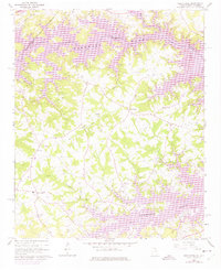
1960 Map of Reed Creek
USGS Topo · Published 1975About this map
Lake Hartwell dominates this mid-century landscape, its sprawling waters filling the valleys of the Tugaloo River and its tributaries along the Georgia and South Carolina border. The map reflects a rural community anchored by numerous country churches and family-named sites, such as Vernon Ch, New Hope Ch, and Mt Harmony Ch. While the rising reservoir reshaped the riverfronts of Hart Co and Anderson Co, the upland areas maintain a dense network of homesteads and small settlements like Reed Creek and Maretts.
Find a feature on this map
25 named features on this map. Tap any name to fly to it.
Don’t see what you’re looking for? This feature index may not catch every label — zoom into the map to look around manually.
Map Details
Editions of this 1960 Reed Creek Map
Other maps of this area

1886 · Walhalla
USGS Topo · 1:125,000

1888 · Pickens
USGS Topo · 1:125,000

1891 · Carnesville
USGS Topo · 1:125,000

1892 · Walhalla
USGS Topo · 1:125,000

1893 · Elberton
USGS Topo · 1:125,000

1894 · Pickens
USGS Topo · 1:125,000

1896 · Walhalla
USGS Topo · 1:125,000

1950 · La France
USGS Topo · 1:24,000

1951 · La France
USGS Topo · 1:24,000

1954 · Greenville
USGS Topo · 1:250,000