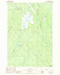
1988 Map of Reed Pond
USGS Topo · Published 1988About this map
Macwahoc Stream and Wytopitlock Stream dominate this northern Maine landscape, winding through the townships of the North Yarmouth Academy Grant and Reed Plt. The settlement of Reed appears in the northeast, marked by a Cem and a nearby transmission line, while the broader terrain is defined by the marshy expanse of Reed Deadwater and the tucked-away Reed Pond. This 1980s-era survey reveals an area primarily used for resource extraction and land management, indicated by several Gravel Pits and a prominent Lookout Tower positioned for forest monitoring. Geologic and topographic features like Clay Bluff and Beech Hill rise above the complex network of minor waterways including Little Meadow Brook and Juniper Brook, illustrating the remote and water-bound character of this Aroostook County wilderness.
Find a feature on this map
27 named features on this map. Tap any name to fly to it.
Don’t see what you’re looking for? This feature index may not catch every label — zoom into the map to look around manually.
Map Details
Editions of this 1988 Reed Pond Map
This is the sole edition of this map. No revisions or reprints were ever made.
Other maps of this area

1940 · Sherman
USGS Topo · 1:62,500

1940 · Mattawamkeag
USGS Topo · 1:62,500

1941 · Mattawamkeag Lake
USGS Topo · 1:62,500

1941 · Wytopitlock
USGS Topo · 1:62,500

1942 · Mattawamkeag
USGS Topo · 1:62,500

1942 · Sherman
USGS Topo · 1:62,500

1943 · Wytopitlock
USGS Topo · 1:62,500

1943 · Mattawamkeag Lake
USGS Topo · 1:62,500

1954 · Millinocket
USGS Topo · 1:250,000

1958 · Millinocket
USGS Topo · 1:250,000
Featured Places
- Reed, Reed Plantation
- Reed Plantation, ME
- Macwahoc Plantation, ME
- Drew Plantation, ME
- Upper Molunkus Township, ME