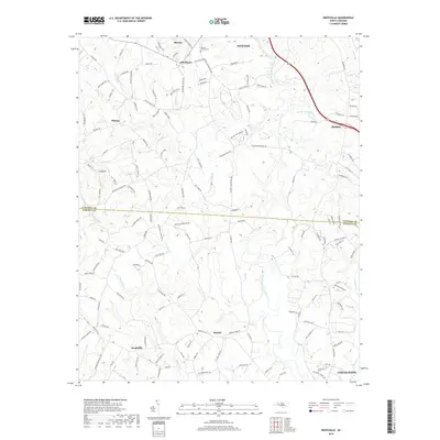
2019 Map of Reepsville
USGS Topo · Published 2019About this map
Rhoney Chapel Cem sits at the northern edge of this landscape, marking a community hub near Rhoney and Blackburn. The terrain is defined by the winding course of the South Fork Catawba River and its numerous tributaries, including Pott Cr and Little Pott Cr, which carve through the Piedmont countryside. Settlement patterns here reflect a mix of established towns and smaller rural junctions like Plateau and Daniels. In the northeast, the town of Maiden is a primary focal point, served by the modern Us 321 corridor and surrounded by landmarks like Bel-Air Pond. The southern portion of the map transitions toward the outskirts of Lincolnton, where Howards Cr and Clark Creek converge. This survey captures a rural region balancing its agricultural roots with modern infrastructure, as seen in the dense network of named family roads and secondary routes that connect these dispersed communities.
Find a feature on this map
139 named features on this map. Tap any name to fly to it.
Don’t see what you’re looking for? This feature index may not catch every label — zoom into the map to look around manually.
Map Details
Editions of this 2019 Reepsville Map
This is the sole edition of this map. No revisions or reprints were ever made.
Other maps of this area

1895 · Hickory
USGS Topo · 1:125,000

1909 · Lincolnton
USGS Topo · 1:62,500

1911 · Lincolnton
USGS Topo · 1:62,500

1914 · Gastonia
USGS Topo · 1:48,000

1916 · Gastonia
USGS Topo · 1:62,500

1953 · Charlotte
USGS Topo · 1:250,000

1954 · Charlotte
USGS Topo · 1:250,000

1960 · Charlotte
USGS Topo · 1:250,000

1962 · Charlotte
USGS Topo · 1:250,000
1970 · Banoak
USGS Topo · 1:24,000