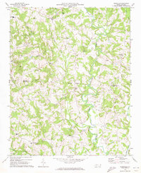
1970 Map of Reepsville
USGS Topo · Published 1973About this map
South Fork Catawba River winds through this Piedmont landscape at the border of Catawba and Lincoln Counties, defining the drainage patterns for numerous family-named creeks. The 1970 landscape is characterized by small rural settlements like Blackburn, Reepsville, and Plateau, which are anchored by a dense network of country churches such as Rhoney Chapel, Wesleyan Chapel, and Rossells Chapel. Educational hubs including Foard High Sch and Union Sch serve the outlying farmsteads and residential clusters. The terrain is notably dissected by watercourses like Pott Creek and Sampson Creek, which influenced the placement of early industry as seen at Howards Creek Mill. Transport in the east is supported by the Southern railroad line, while the remainder of the quadrangle relies on a web of secondary roads connecting these historic community centers.
Find a feature on this map
36 named features on this map. Tap any name to fly to it.
Don’t see what you’re looking for? This feature index may not catch every label — zoom into the map to look around manually.
Map Details
Editions of this 1970 Reepsville Map
This is the sole edition of this map. No revisions or reprints were ever made.
Other maps of this area

1895 · Hickory
USGS Topo · 1:125,000

1909 · Lincolnton
USGS Topo · 1:62,500

1911 · Lincolnton
USGS Topo · 1:62,500

1914 · Gastonia
USGS Topo · 1:48,000

1916 · Gastonia
USGS Topo · 1:62,500

1953 · Charlotte
USGS Topo · 1:250,000

1954 · Charlotte
USGS Topo · 1:250,000

1960 · Charlotte
USGS Topo · 1:250,000

1962 · Charlotte
USGS Topo · 1:250,000
1970 · Banoak
USGS Topo · 1:24,000