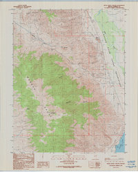
1988 Map of Reese River Canyon
USGS Topo · Published 1988About this map
Wassuk Range peaks dominate the western half of this Nevada landscape, where high elevations like Bald Mountain overlook a complex network of drainage systems. The terrain transitions sharply from these heights into the canyons of the eastern slopes, including Penrod Canyon and Deadman Canyon, which lead toward the desert floor. The map highlights the eastern edge of the mountains meeting the plains of the Walker River Indian Reservation, a significant cultural and geographic boundary in Mineral County.
Find a feature on this map
15 named features on this map. Tap any name to fly to it.
Don’t see what you’re looking for? This feature index may not catch every label — zoom into the map to look around manually.
Map Details
Editions of this 1988 Reese River Canyon Map
This is the sole edition of this map. No revisions or reprints were ever made.
Other maps of this area

1909 · Hawthorne
USGS Topo · 1:250,000

1911 · Hawthorne
USGS Topo · 1:250,000

1915 · Hawthorne
USGS Topo · 1:250,000

1948 · Walker Lake
USGS Topo · 1:250,000

1955 · Hawthorne
USGS Topo · 1:62,500

1956 · Mt. Grant
USGS Topo · 1:62,500

1957 · Walker Lake
USGS Topo · 1:250,000

1962 · Walker Lake
USGS Topo · 1:250,000

1964 · Walker Lake
USGS Topo · 1:250,000

1964 · Gillis Canyon
USGS Topo · 1:62,500