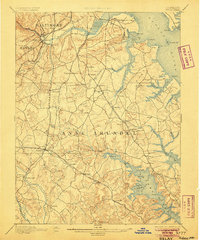
1894 Map of Relay
USGS Topo · Published 1905About this map
The Patapsco River serves as the central artery for this late 19th-century landscape, separating Baltimore from the developing northern reaches of Anne Arundel and Howard counties. This era is defined by a dense web of competing rail lines, including the Baltimore and Ohio R.R. and the Annapolis and Baltimore Short Line R.R., which facilitated the growth of inland settlements like Linthicum and Glenburnie. Along the shoreline, Elkridge Landing stands as a point of interest, while the coastal reaches are dotted with maritime aids such as Ft. Carroll Light. The terrain transitions from the industrial outskirts of South Baltimore to the tidal inlets of the Magothy River, where landmarks like Mt. Misery overlook Round Bay. This detailed study captures the region before suburban expansion altered the local geography of Wellham Cross Roads and Severn.
Find a feature on this map
100 named features on this map. Tap any name to fly to it.
Don’t see what you’re looking for? This feature index may not catch every label — zoom into the map to look around manually.
Map Details
Editions of this 1894 Relay Map
4 editions found
Other maps of this area

1892 · Laurel
USGS Topo · 1:62,500

1892 · Ellicott
USGS Topo · 1:62,500

1892 · Owensville
USGS Topo · 1:62,500

1892 · Annapolis
USGS Topo · 1:62,500

1893 · North Point
USGS Topo · 1:62,500

1893 · Gunpowder
USGS Topo · 1:62,500

1894 · Ellicott
USGS Topo · 1:62,500

1894 · Laurel
USGS Topo · 1:62,500

1894 · Baltimore
USGS Topo · 1:62,500

1894 · Relay
USGS Topo · 1:62,500